Austin Digital Twin
Collaborating to Create a Digital Twin for Austin, Texas
Collaboration between City of Austin, UT Austin, TeXUS Lab, and Urban Info Lab
Team: Ryan Hardesty Lewis, Junfeng Jiao, Dev Niyogi, Justice Jones, Braniff Davis
INTRODUCTION
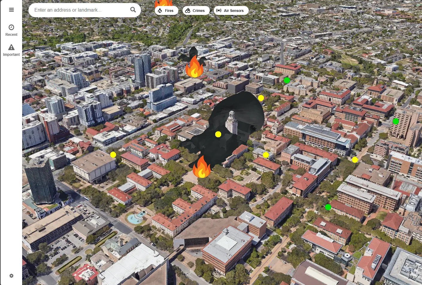
The Austin Digital Twin is an interactive, real-time 3D map that brings the city to life by integrating data streams from various sources. Users can visualize crucial elements like fires, police activity, and live traffic, unlocking a new level of situational awareness. This empowers both residents and officials to make swift, data-informed decisions—fundamentally transforming the way we monitor urban dynamics and manage public safety through an interactive and real-time 3D map.
INITIAL CONCEPT
The overarching goal is to harness advanced data analytics and geospatial tools to create a comprehensive model of Austin, enabling more resilient urban planning and community engagement. By merging data from Zillow (real estate), Austin Police (crime stats), the fire department (emergency response), and Google 3D Tiles (geospatial), the digital twin provides a multifaceted picture of how urban, social, and economic factors converge in real time. This holistic approach provides real-time data streams to inform decision-making and make combined predictions about future urban dynamics, such as crime's impact on property values or emergency response times.
TECHNOLOGY & IMPLEMENTATION
Built on a foundation of geospatial data processing, machine learning, and intuitive user interfaces, the Austin Digital Twin unifies critical metrics into a single 3D representation. These data points form a mirror of city life that can be visualized, analyzed, and even predicted. Notably, this project was created after the release of Google 3D Tiles, providing one of first implementations for interfacing with these photorealistic 3D Tiles in a digital twin. Google 3D Tiles, which are derived from Google Earth, provide a high-fidelity precision model for exploring neighborhood-level changes.
The system also compiles new vital statistics—like average fires or crimes per neighborhood—into a central dashboard, giving planners, policymakers, and everyday Austinites immediate insight into evolving community needs and challenges.
RESULTS & IMPACT
With real-time feeds from police, fire, and traffic agencies, the Austin Digital Twin has redefined how the city navigates public safety and resource allocation. By correlating real estate trends with crime or emergency incidents, the platform predicts shifts in property values, enabling residents and investors to stay informed about potential risks and opportunities. Policymakers gain a clearer sense of where to deploy additional community services or implement resilience measures.
This holistic approach has already shown tangible benefits, including better coordination among emergency responders and data-driven decisions on future development. By illuminating patterns like high fire incidence near older infrastructure or crime hotspots tied to changing social demographics, the digital twin fosters collaboration and effective long-term planning for a more equitable Austin.
PROTOTYPE
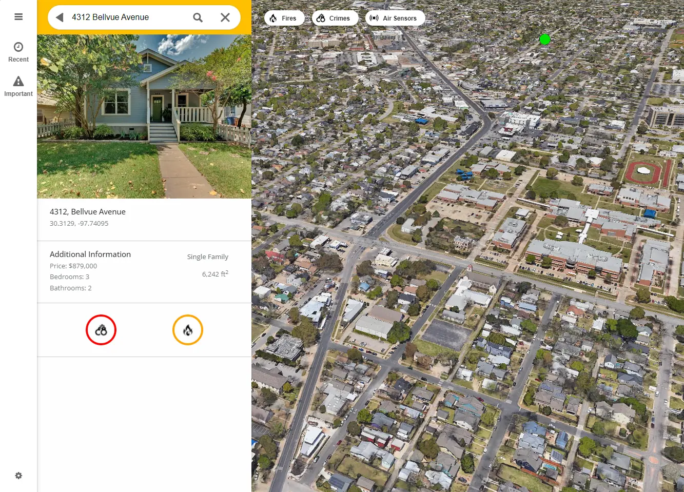
Available at austindigitaltwin.com, our current prototype boasts an accessible interface akin to popular mapping platforms. Users can view properties of interest, see Street-level images (courtesy of Mapillary), visualize data in interactive charts, or filter events for analysis. This customization enables a variety of users to gain insights, whether they’re local officials, real estate professionals, or curious citizens.
ACKNOWLEDGEMENTS
Special thanks to the City of Austin and Austin Fire Department for their collaboration. We also appreciate the support of the Jackson School of Geosciences and the TeXUS Lab for their contributions to this project.