CROWDSOURCED STREETVIEW
Integrating Real-Time Imagery Updates
into Google Streetview
Published in SIGGRAPH 2024 Proceedings
Team: Ryan Hardesty Lewis
INTRODUCTION
Google Streetview provides a sweeping panorama of streets worldwide, yet it often lags behind the realities on the ground. This gap becomes especially evident after major events—like natural disasters or rapid urban development—where Streetview imagery can be out of date for months, if not years. Crowdsourced Streetview tackles this limitation by integrating timely, user-generated images from social media, effectively layering real-time photos onto the familiar Google Streetview interface. The result is an ever-evolving window into the world, refreshed by crowdsourced contributions, suitable for both casual real-time use and disaster response applications.
INITIAL CONCEPT
The idea for Crowdsourced Streetview came after a severe coastal storm had reshaped a friend’s hometown, yet Google Streetview still displayed the old, unaltered coastline. In an effort to show me the havok the storm had caused, he could only show me sparse separated images and their original locations on Streetview. By tapping into the power of social media, we realized that countless geotagged images exist in real time but remain siloed on various platforms. Our concept merges these fresh visuals with Google’s panoramic layers, transforming Streetview into an up-to-date reflection of what users are actually seeing on the ground. This innovation not only caters to curious browsers but also aids emergency responders, journalists, and local communities seeking current information after critical incidents.
The idea is simple yet powerful: let everyday users snap photos that automatically update Streetview. When big events like parades, floods, or construction projects alter the face of a neighborhood, those changes become visible on Streetview without the traditional months-long update cycle. Our pipeline automatically aligns new images with the existing Streetview geometry, courtesy of real-time computer vision algorithms, so the platform stays constantly refreshed and relevant.
TECHNOLOGY & IMPLEMENTATION
Crowdsourced Streetview depends on two major building blocks: a pipeline for collecting relevant images, and a homography-based alignment system. First, the collection module continuously monitors geotagged social media posts, indexing photos that match either a defined location or a user’s chosen radius, usually through hashtags or EXIF data. This ensures we only retrieve images with sufficient resolution and metadata to be properly fused onto Streetview’s panoramas.
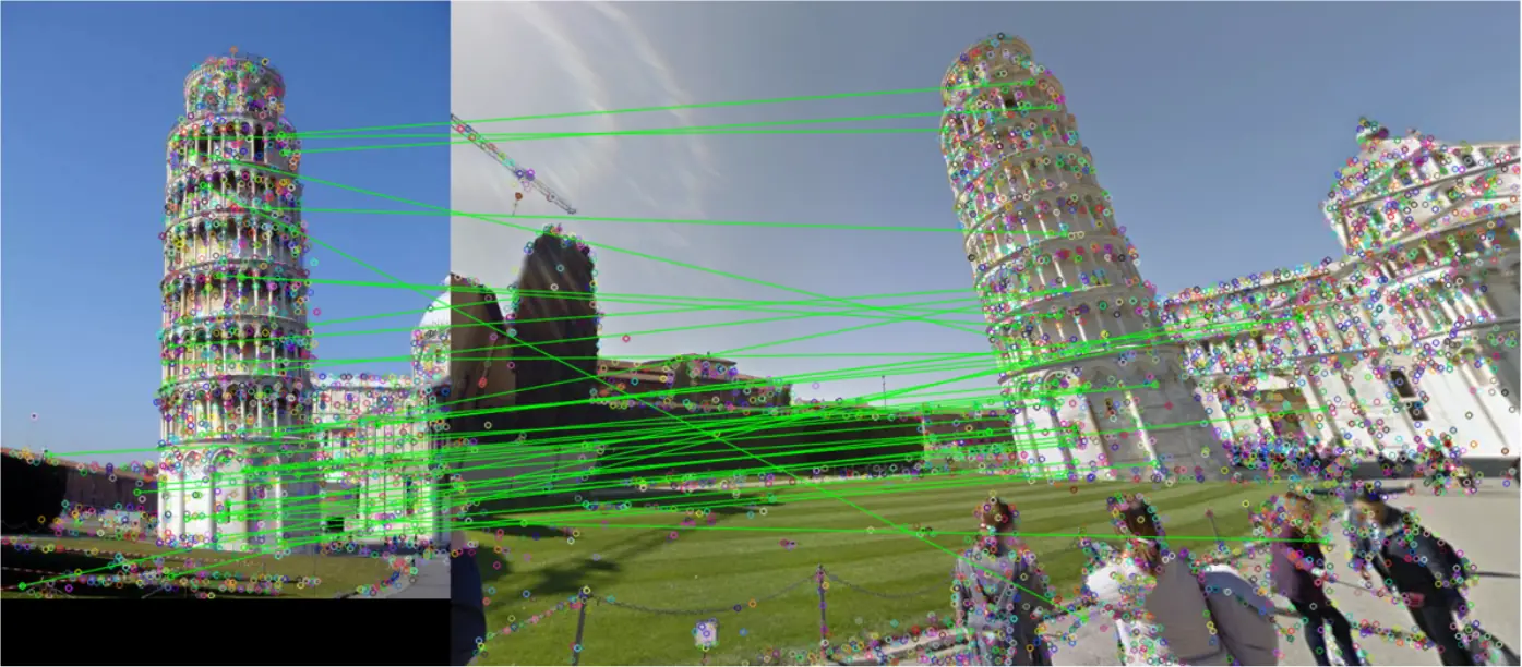
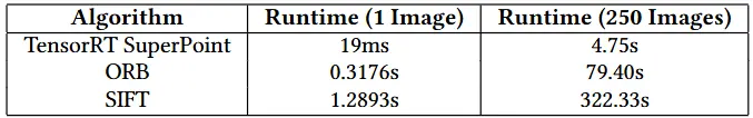
Next, the alignment module deploys feature detection and homography estimation using the OpenCV library, leveraging performance enhancements like TensorRT-accelerated SuperPoint. These algorithms locate common keypoints in both the new imagery and the existing Streetview panoramas—aligning them in real time, often in under 20ms per image, which is absolutely vital when doing hundreds of comparisons. Our approach is robust enough to account for differences in lighting, partial occlusions, and even slight viewpoint variations. By intercepting network calls via Puppeteer in a Python environment, newly processed tiles are sent back to Streetview’s browser client. This seamless process allows users to pan around and discover up-to-date visuals without needing additional software.
RESULTS & IMPACT
Performance evaluations reveal that crowdsourced images can be aligned rapidly, especially when harnessing GPU-accelerated methods. User feedback during our pilot launch indicates a strong appetite for more immediate, hyperlocal updates—particularly among city officials and event organizers who benefit from real-time visuals. While the variability in user-uploaded images poses a challenge, ongoing research into AI-based quality filtering holds promise. Our vision is to one day see entire neighborhoods crowdsourcing fresh imagery daily, offering a living, breathing map that truly reflects the pace of change.
Crowdsourced Streetview has use cases extending far beyond curiosity and aesthetics. Disaster response agencies can quickly access on-the-ground imagery of impacted areas, while civic planners might rely on near-instant updates to gauge infrastructure conditions or track construction progress. Eventually, the platform could incorporate additional data layers—such as traffic or environmental metrics—opening the door for a more informed, real-time, and more relevant digital mapping experience.
VIDEO
ACKNOWLEDGEMENTS
We acknowledge Google LLC for Streetview data usage under fair use.
Special thanks to all our alpha testers who contributed geotagged images!